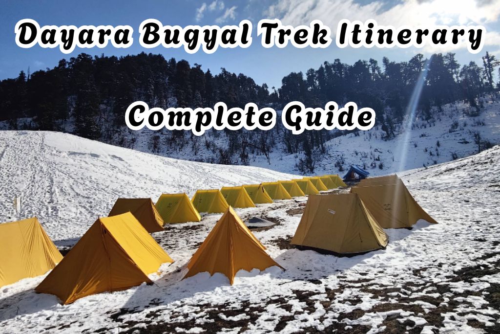
Dayara Bugyal Trek Itinerary: Complete Trail Guide & Route
 TheFellow Traveler
01 Jan, 2026
14 mins read
91
TheFellow Traveler
01 Jan, 2026
14 mins read
91

Dayara Bugyal is among the most stunning alpine grasslands of the Himalayan region, located in the Uttarakhand state. Known for its vast bugyal meadows, rolling mountain meadows, and dramatic Himalayan views, Dayara Bugyal is not just a trek—it is a walk through one of Earth’s most beautiful natural landscapes and fragile ecosystems.
This blog presents a fact-accurate Dayara Bugyal trek itinerary with a realistic trail description, aligned with on-ground experience, while also explaining the ecological and natural significance of the grassland ecosystem you walk through.
Dayara Bugyal Trek Overview
- Region: Garhwal Himalayas, Uttarakhand
- Base Village: Raithal
- Maximum Altitude: 12,400 ft (Bakariya Top)
- Trek Duration: 3–4 Days
- Trek Distance: 18–22 km
- Difficulty: Easy to Moderate
- Landscape Type: Alpine pastures & natural grasslands
Dayara Bugyal’s Grassland Ecology
Dayara Bugyal is a textbook example of alpine ecology in the Himalayan region. Located at high altitude, this landscape survives under tough environmental conditions where oxygen levels are low, winds are strong, and winters are long and harsh.
Unlike forests, these alpine grasslands develop in zones where tree growth is naturally limited. The vegetation here adapts to freezing temperatures, seasonal snowfall, and short growing periods. What you see as open green meadows is actually a carefully balanced grassland ecosystem shaped by climate, altitude, and time.
These alpine grasslands:
- Exist at high elevation where trees struggle to grow
- Are shaped by snowfall, freezing temperatures, and rainfall patterns
- Support grass species and other herbs that survive extreme cold
- Depend on controlled grazing for grass regeneration
For centuries, controlled livestock grazing by local communities has helped maintain these bugyal meadows. However, excessive human activity, careless camping, and off trail walking can disturb these fragile ecosystems. Because grass growth and soil recovery are slow at high altitude, conservation awareness and responsible trekking are essential for long term environmental protection and conservation importance of alpine pastures.
Day-wise Itinerary & Trail Description of Dayara Bugyal trek
The Dayara Bugyal trek trek is usually done within 3 to 4 days starting from Dehradun and Raithal/Barsu onwards. Some prefer it about 5 or 6 days for more exploration. Below is the itinerary of 4 days.
Day 1: Drive from Dehradun to Raithal
- Drive Distance: 183 km
- Drive Duration: 7–8 hours
- Altitude: 5,905 ft
The journey begins early from Dehradun, following the scenic mountain road that runs alongside the Bhagirathi River. The drive passes through Landour, Chinyalisaur, and Uttarkashi, offering a gradual transition from plains to high-elevation Himalayan terrain.
A major highlight of the drive is Moriana Top (Tingling Point), where the surrounding natural topography opens up to reveal sweeping Himalayan views. Peaks such as Bandarpunch, Black Peak, Srikanth, and the Gangotri range are clearly visible, and on exceptionally clear days, distant views of Chaukhamba or Nanda Devi can also be seen.
At Chinyalisaur, the vast stretch of the Tehri Dam reservoir dominates the landscape before the road climbs again toward Uttarkashi. Uttarkashi serves as the last major town with ATM facilities, shops, and medical access. A brief visit to the Kashi Vishwanath Temple is often part of the journey.
By evening, you reach the quiet mountain village of Raithal, surrounded by terraced fields and forested slopes. Dinner and overnight stay are arranged here, offering insight into local Garhwali culture.
Day 2: Trek from Raithal to Gui Campsite
- Trek Distance: 5 km
- Trek Duration: 4–5 hours
- Altitude: 9,630 ft
The trek begins after breakfast from Raithal village. After clicking a photo at the official Dayara Bugyal trek entry point, the trail gradually ascends through dense forests dominated by oak and rhododendron.
Early on the trail, you pass the Nag Devta Temple, a culturally important site where locals and trekkers offer coins and prayers at a tree dedicated to the serpent deity. A natural water point nearby serves as a refreshment stop.
This section of the trail is rich in plant species, other herbs, and forest vegetation. During spring, the rhododendron forest bursts into color, while in summer, the greenery reflects healthy grass growth supported by seasonal rainfall.
The trail is well-maintained and steadily climbs through forest cover, offering glimpses of local wildlife and birds. After 4–5 hours, the forest opens up near Gui Campsite, an alpine clearing surrounded by high-elevation slopes. Sunset views from Gui include Srikanth and Gangotri peaks glowing against the evening sky.
Day 3: Trek from Gui to Dayara Top and Bakariya Top, Return to Gui
- Trek Distance: 12 km (round trip)
- Trek Duration: 7–8 hours
- Altitude: 12,000 ft (Dayara Top), 12,400 ft (Bakariya Top)
This is the most rewarding and scenic day of the trek. From Gui, the trail moves gradually upward toward Chilapada, after which the landscape transforms dramatically. Dense forests give way to vast alpine grasslands, marking the beginning of the Dayara Bugyal region.
Dayara Bugyal represents a grassland ecosystem where dominant grasses like Gidara Bugyal and other native grasses form the primary plant community. These grasslands are a natural occurrence, found across Earth’s biomes, on every continent except Antarctica.
As you climb, the terrain becomes gently sloped, shaped by freezing temperatures, snowfall, and seasonal weather patterns. The open meadow reflects classic landscape dominance of natural grasslands, unlike agricultural land, which is shaped by intensive human modification.
After a final steep ascent, you reach Dayara Top, offering a 360-degree panorama of Bandarpunch, Kala Naag, Srikanth, and the Gangotri range. The vastness of Dayara Bugyal spreads out below, showcasing one of the finest alpine pastures in the Himalayas.
If time and weather permit, the trail continues further to Bakariya Top, the highest point of the trek. From here, the views are even more expansive, highlighting the raw beauty of high-altitude natural landscapes.
Seasonally, the bugyal transforms dramatically:
- Summer months: Lush green grass and active grazing zones
- Flower bloom season: Meadows filled with seasonal flowers and rich floral cover
- Autumn: Golden and orangish hues dominate the landscape
- Winter season: Completely snow covered, ideal for snow trekking and skiing
Large herds of sheep and cattle can often be seen during summer and monsoon, reflecting grazing-maintained ecosystems that support tribal herdsmen, livestock grazing, and traditional mountain livelihoods.
After spending several hours exploring the meadows, you descend back to Gui Campsite for the night.
Day 4: Trek from Gui to Raithal and Drive to Dehradun
- Trek Distance: 5 km
- Trek Duration: 2–3 hours
- Altitude: 5,905 ft
The final day begins with a gradual descent from Gui back to Raithal, retracing the same forest trail. The downhill walk is comfortable and allows trekkers to absorb the forest atmosphere one last time.
After reaching Raithal, a short rest is followed by the drive back to Dehradun, which usually takes 6–7 hours depending on road and traffic conditions.
Note: Plan onward travel from Dehradun after 9 PM, as delays can occur during the return journey.
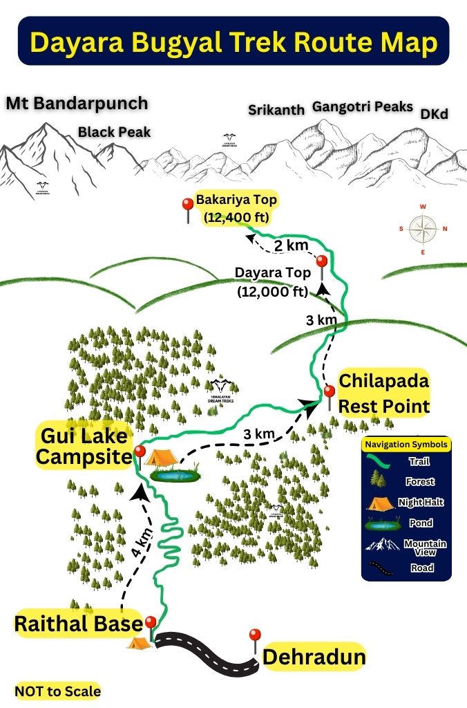
Dayara Bugyal Trek Route Map
The Dayara Bugyal trek follows a clearly defined route that begins at Raithal village, ascends to Gui Campsite, and then continues to Dayara Bugyal Top or further to Bakariya Top. After exploring the meadows and viewpoints, the trail retraces the same path, descending back to Gui and finally returning to Raithal.
The route map below clearly illustrates the trekking path, along with the total distance covered and the elevation gain and loss at each stage of the trek.
Frequently Asked Questions About Dayara Bugyal Trek
What type of ecosystem is Dayara Bugyal?
Dayara Bugyal is a natural grassland ecosystem and part of the alpine biomes of the Himalayan region. The landscape is dominated by grasses and small plant species rather than trees.
Are these grasslands natural or created by humans?
These are natural grasslands shaped by altitude, climate, and environmental conditions. Controlled cattle grazing has historically helped maintain the vegetation, but the ecosystem itself is natural.
Why are bugyal meadows important?
Bugyal meadows play an important role in water retention, soil stability, and supporting biodiversity. Their ecological sensitivity makes them vital for maintaining balance in Himalayan landscapes.
When is the best time to visit Dayara Bugyal?
The best time depends on what you want to experience.
- For green grass and flower bloom: Late May to August
- For clear views and pleasant weather: September to October
- For snow covered landscapes and snow trekking: December to February
Is Dayara Bugyal suitable for beginners?
Yes. The trek is considered easy to moderate. The trails are gradual, well defined, and ideal for first time trekkers with basic fitness.
How difficult is the Dayara Bugyal trek?
The difficulty level is easy to moderate. There are no technical sections, but the long walking hours on Day 3 require reasonable stamina.
How much does the Dayara Bugyal trek usually cost?
Trek packages generally range between INR 6,000 to INR 12,000 depending on season, inclusions, and trek duration. This usually covers accommodation, meals, guides, permits, and transport from Dehradun.
How do I reach the base village Raithal?
You need to reach Dehradun first.
Dehradun is well connected by train and flight
From Dehradun, Raithal is around 180 km and takes 7 to 8 hours by road
Uttarkashi is the last major town with ATM facilities
What should I pack for the trek?
Some essential items include:
- Warm layers, even in summer
- Good trekking shoes with grip
- Rain protection during monsoon months
- Sunscreen, sunglasses, and cap
- Personal medicines and basic first aid
Packing light but smart is important because this is a high altitude trek.
Why is conservation important in alpine pastures?
Alpine pastures regenerate very slowly due to short growing seasons. Even small damage to vegetation can take decades to recover. Responsible trekking helps protect these natural landscapes for future generations.
Written By:
TheFellow Traveler

Hotels at your convenience
Now choose your stay according to your preference. From finding a place for your dream destination or a mere weekend getaway to business accommodations or brief stay, we have got you covered. Explore hotels as per your mood.